Southern Edwards Plateau Habitat Conservation Plan

As of April 2017, the plan is available for endangered songbird and karst invertebrate coverage for projects in Karst Zones 3-5 in San Antonio, Bexar County, Texas. As of May 1, 2017, the plan is still awaiting establishment of Karst Fauna Areas (KFAs; karst preserves) for bird and karst coverage in Karst Zones 1-2 in San Antonio, Bexar County, Texas.
This article is a summary of the plan and participation requirements. For complete details, please refer to the habitat conservation plan. Download link below:
PDF Copy of HCP Document
This article is a summary of the plan and participation requirements. For complete details, please refer to the habitat conservation plan. Download link below:
PDF Copy of HCP Document
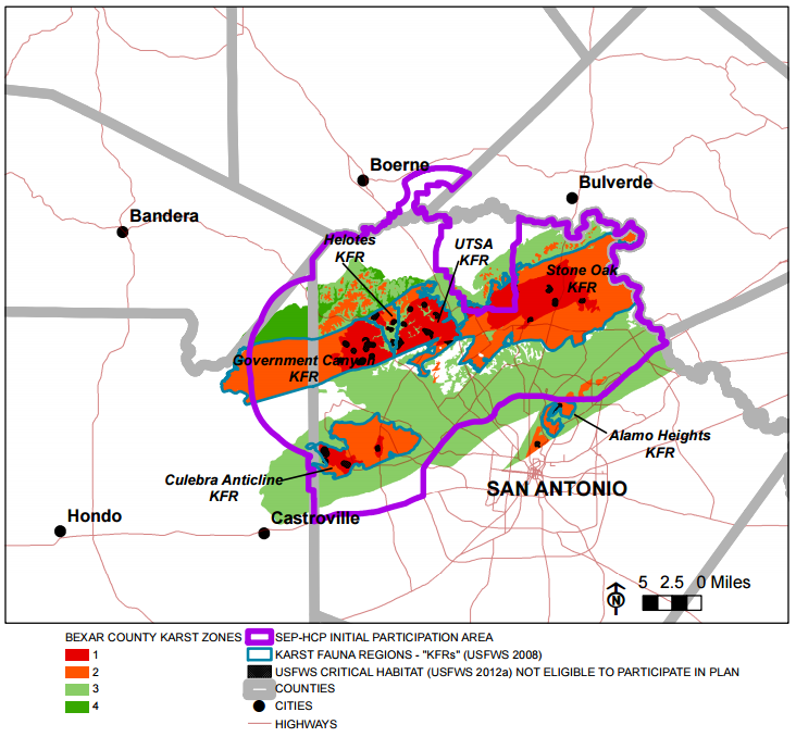
Karst Zones in Bexar County
Initial Participation Area
Covered Species
Avian Species
Karst Invertebrates
- Golden-cheeked Warbler (Setophaga chrysoparia; GCWA)
- Black-capped Vireo (Vireo atricapilla; BCVI)
Karst Invertebrates
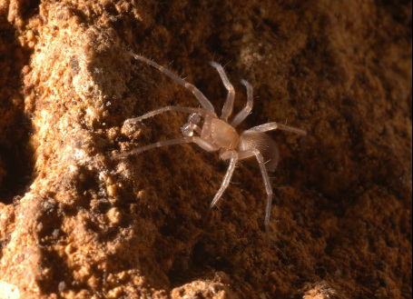
- Government Canyon Bat Cave spider (Tayshaneta [formally Neoleptoneta] microps)
- Madla Cave meshweaver (Cicurina madla)
- Braken Cave meshweaver (Cicurina venii)
- Government Canyon Bat Cave meshweaver (Cicurina vespera)
- Rhadine exilis (a beetle with no common name)
- Rhadine infernalis (a beetle with no common name)
- Helotes mold beetle (Batrisodes venyivi)
Requirements for SEP-HCP Participant Application
- Evidence of authority from landowner to applicant, if applicant is different than landowner.
- Central Appraisal District map with the property and Tax Parcel ID number(s) of the property highlighted.
- Legal description.
- A legible survey and metes and bounds description of the property prepared by a registered public licensed surveyor in the State of Texas.
- Geological Assessment for the property prepared by a professional geoscientist licensed in the State of Texas (if over the Edwards Aquifer Recharge Zone).
- Karst habitat assessment and surveys performed in accordance with current U.S. Fish and Wildlife Service (USFWS) protocols, and the following:
- Identifies known karst features and USFWS designated critical habitat units located over or within 750-ft of the property
- Confirms evaluation or excavation was performed to determine if any identified features provide habitat for any of the covered karst
invertebrates
- Provides evidence of named, gated, or previously identified caves as containing any of the covered karst invertebrates
- Provides a survey report for the caves on the property performed by a USFWS-permitted biologist determining presence/absence of the
covered karst invertebrates
- Provides a map of the footprint of any caves within the property
- Documentation confirming the property and surrounding areas within 300 feet of the property has been evaluated in the last 2 years by a USFWS-permitted biologist for suitable habitat for the Golden-cheeked Warbler and Black-capped Vireo.
- Documentation of presence/absence survey for both the Golden-cheeked Warbler and Black-capped Vireo conducted in accordance with USFWS protocols by a USFWS-permitted biologist in the last 2 years (if applicable).
- Proposed development plan that includes square footage or acreage of limit of clearing (limit of clearing is any area within which any type of clearing or land disturbance will occur, e.g., area for erosion controls, driveways, utilities, structures, etc.).
- Completed Right of Entry form authorizing representatives of SEP-HCP to enter the property.
- Any additional information that may be useful in evaluating participation and possible mitigation levels, including whether the use of the property proposes unusually low impervious cover; the existing karst features have suffered previous encroachment, and other pertinent information.
- Application fees.
Cost for Participation for Endangered Songbird Coverage
- Direct Impacts – all GCWA and BCVI habitat on a property identified during the habitat assessment is assumed to be directly impacted unless a presence/absence survey is performed demonstrating absence. Direct impacts are mitigated at a 2:1 ratio. Therefore, if you have 10 acres of habitat on the property that will be directly impacted, you will purchase credits for 20 acres from an approved mitigation bank.
- Indirect Impacts – all GCWA and BCVI habitat within identified within 300 feet of a property or habitat on a property with negative presence/absence survey results is assumed to be indirectly impacted by a project. Indirect impacts are mitigated at a 0.5/1 ratio. Therefore, if you have 10 acres of habitat on the property that will be indirectly impacted, you will purchase credits for 5 acres from an approved mitigation bank.
Cost for Participation for Karst Invertebrate Coverage
Participation fee for karst of $1000.00/acre within Karst Zones 1-4.
Fee for impacts within Karst Zones A or B of a known occupied cave
There is also an option of 'land-in-lieu of fees', which means an applicant can set up a preserve around a known, occupied feature or endangered bird habitat area instead of pay the mitigation fee if the area meets the minimum requirements for recovery-quality karst preserves and/or GCWA/BCVI conservation banks.
Fee for impacts within Karst Zones A or B of a known occupied cave
- $400,000 for impacts within 0-345 feet of a known occupied cave
- $40,000 for impacts within 346-750 feet of a known occupied cave
- Also considered on a case-by-case basis.
There is also an option of 'land-in-lieu of fees', which means an applicant can set up a preserve around a known, occupied feature or endangered bird habitat area instead of pay the mitigation fee if the area meets the minimum requirements for recovery-quality karst preserves and/or GCWA/BCVI conservation banks.
- Minimum requirements for karst: includes at least 345 feet around the footprint of a cave with high quality preserves having a minimum of 100 acres of native vegetation around the cave footprint and a medium quality preserve having a minimum of 40 acres of native vegetation around the cave footprint. Also considered on case-by-case basis.
- Minimum requirements for birds: at least 500 acres of occupied habitat for GCWA; must support moderate-sized, managed population for BCVI. Minimum acreage must be either on the property or an aggregate total including protected habitat on neighboring properties.
Minimization Efforts and Restrictions
- Endangered songbirds – seasonal clearing and construction restrictions from March 1 – July 31 for GCWA habitat and March 15 – August 31 for BCVI habitat. Oak wilt prevention following the Texas Forest Service’s guidelines.
- Karst invertebrates – Install fencing and sedimentation controls. Occupied cave zones and Critical Habitat areas are subject to avoidance and minimization measures.
invertebrates that may occur in association with occupied karst features discovered during construction, where such features were not
identified during the required pre-application karst surveys. However, there is a mandatory 7 day work stoppage within 50 feet of a feature
discovered during construction to allow the Plan's administrators to gather important biological data on the feature (at the cost of the SEP-
HCP administrators). If the feature is found to be occupied by a listed species during that time, there may be additional minimization efforts
requested, if the karst feature will not be completely removed during construction.

